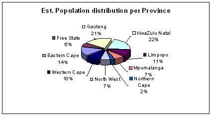
MunicipalitiesAccording to Statistics South Africa (2007), South
Africa's largest provincial population resides in
KwaZulu-Natal with just 10 million people. This is
equivalent to 20.9% of the total population of 47.9
million.
The capital of the Kwa-Zulu Natal is Pietermaritzburg.
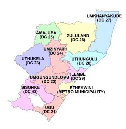
Kwa-Zulu Natal is divided into 11 municipalities of which
eThekwini is a metropolitan municipality and the other 10
are district municiplalities.
eThekwini Metropolitan MunicipalityeThekwini Metropolitan Municipality which was created in
2000, includes the city of Durban
and its surrounding towns. The eThekwini Municipal Area
(EMA) is an amalgamation of seven council areas and some
tribal land. It covers an area of 2,297 square
kilometres. It stretches from Umkomaas in the south to
Tongaat in the north and Cato Ridge in the West, and
includes some tribal areas in Umbumbulu and Ndwedwe. The
majority of its 3,090,000 people speak Zulu (2001 Census).
eThekwini is the main economic driver in
KwaZulu-Natal, contributing to over half of the province's
output, employment and income. In national terms, Durban
is the second most important economic hub after
Gauteng, accounting for 15% of national output, 14% of
household income and 11% of national employment. Regional
development corridors are based on rail and road links
Durban
northwards to Richards Bay and Maputo, and westward to
Pietermaritzburg and Johannesburg. The Port of Durban is
the busiest general cargo port in South Africa and the
busiest container port in the Southern Hemisphere.
The 10 district municipalities in the EMA are:
-Ugu
-Amajuba
-iLembe
-Uthukela
-Umzinyathi
-Zululand
-Umkhanyakude
-uThungulu
-Umgungundlovu
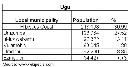
-Sisonke UguThe municipal headquarters of the Ugu district are in Port
Shepstone.
The majority of its 704,000 people speak IsiZulu (2001
Census). The area is 5,866 square kilometres in extent,
and boasts a coastline of 112 kilometres. It is bordered
on the north by the eThekwini Municipality; the west by
the uMgungundlovu and Sisonke District Municipalities; the
south by the Eastern Cape Province; and the east by the
Indian Ocean. The Ugu District Municipality consists of
81 municipal wards which culminate into six local
municipalities. The district contains the following local
municipalities:
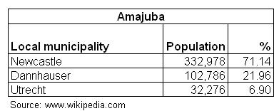
AmajubaAmajuba is home to the industrial town of Newcastle (the
municipal headquarters) and its surrounding coalfields.
The surrounding hinterland consists predominantly of
commercial farms. The other towns are Utrecht and
Dannhauser. The district contains the following local
municipalities:
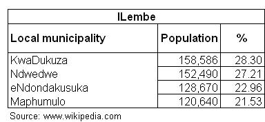
ILembeThe municipal headquarters of iLembe is in KwaDukuza
(Stanger). Ilembe District Municipality has a population
of 560,000 and is the smallest of the 10 district Councils
in
KwaZulu-Natal. It is bordered by the eThekwini
Metropolitan Municipality in the immediate south and
linked to Richards Bay in the north by the coastal
highway. This means that the district Municipality has
good access to two major harbours (Durban and Richards
Bay) as well as to the existing Durban International
Airport and the future King Shaka International Airport.
Key to its economic potential is its position,
strategically placed between Durban and Richards Bay. The
core agricultural activites are sugarcane, vegetables,
tunnel farming, flowers and nurseries. The industrial
heart of the area is near Mandeni, where paper and sugar
mills dominate.
The district contains the following local municipalities:
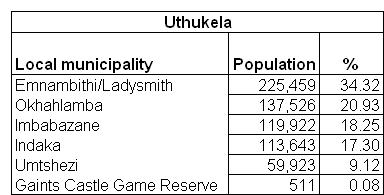
UthukelaUthukela Municipality is headquartered in Ladysmith. It
has a population of 657,000 and contains the
following local municipalities:
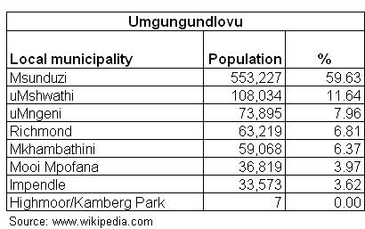
UmgungundlovuThe seat of this municipality is Pietermaritzburg. South
Africa’s busiest arterial - the N3 runs through
the district municipality, linking the country’s
industrial
heartland of Gauteng to Durban, the largest port in the
southern hemisphere.
The manufacturing activity is largely concentrated around
Pietermaritzburg. The dominant clusters include leather,
aluminium products, chemicals, food and
furniture. The agricultural sector contributes 12.4% to
the economy of the district and is significant when
compared with 5% at the national and provincial levels.
Commercial agriculture is dominated by sugarcane, animal
products and forestry.
The district, with a population of 928,000, contains the
following local municipalities:
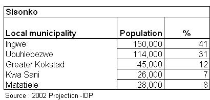
SisonkeIxopo is the headquarters of the Sisonko Municipality.
The population is 363,000, and the main commercial
activity is agriculture which includes cattle, poultry,
citrus, sugarcane and fruit. The district contains the
following local municipalities:
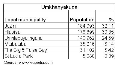
UmkhanyakudeThe main centre of Umkhanyakude is Mkuze. Umkhanyakude
District is situated in the north-eastern part of KwaZulu-
Natal, extending from the Mfolozi River up to the
Mozambique border, being bonded on the east by the Greater
St Lucia Wetland Park which is the first world heritage
site in South Africa along the Elephant Coast. The
population is 573,000.
The main forms of commercial agriculture are sugarcane and
timber, with cotton, sisal and pineapples also grown.
However, commercial agriculture occupies only about 275
square kilometres (2.5%) of the total area. Sugarcane is
undergoing an expansion in the Mkuze District with the
construction of a pipeline for irrigation from the Pongola
Dam.
The district contains the following local municipalities:
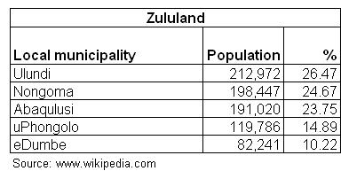
ZululandThe municipal headquarters are in Ulundi. The district
extends along the coast of the Indian Ocean from the
Tugela River in the south to the Pongola River in the
north. With a population of 804,000, the district
contains the following local municipalities:
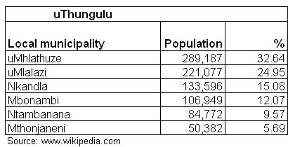
uThunguluRichards Bay is the Uthungulu municipality’s
headquarters. The population is 886 000. The main
commercial agricultural crop is sugarcane, confined to
the lower lying coastal belt. The production of
horticultural crops includes citrus, sub-tropical fruits
and vegetables in irrigated areas. Forestry is classified
as commercial (largely found in the non-tribal areas) and
small grower timber production (found in the tribal
areas). The industry is centred around Richards Bay and
Empangeni which are also the urban areas along with
Esikhaweni, Eshowe, KwaMbonambi, Nkandla and Ntambanana.
Economic activities are manufacturing, mining, the port,
agriculture and forestry. The manufacturing and mining
sectors are located around the port of Richards Bay which
is essentially an export port for bulk mining.
The district contains the following local municipalities:
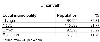
UmzinyathiUmzinyathi district municipality is based in Dundee. It
has a population of 456,000, and contains the following
local municipalities:
|